- Home
- Breaking News
- Bylaws
- About WSSM
- Community Events
- Consumer Alerts
- Crime
- Neighborhood Watch
- Disaster Preparedness
- Area Development Projects
- Transportation & Traffic including Major Construction Updates
- Environmental Quality
- Government Updates
- City Services
- Community links - Resources
- Our Schools
- Our Elected Officials
- WNC
- Volunteer
- New from our nearby business neighbors
- Contact us
 Westwood South of
Santa Monica Blvd.
Homeowners Association
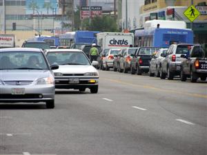
Transportation & Traffic
HAS A NEW WEBSITE!
This website is out of date and serves as an archive.
_______________________________________
WESTSIDE MOBILITY STUDY wants your input:
Three community meetings were held in early October 2012 to give feedback on the work being done for the Westside Mobility Study. If you were not able to attend one of these meetings, you are invited to view the presentation given and to see the slides that were on display so that you can submit COMMENTS to the project.
Go to:
http://www.westsidemobilityplan.com/participate-in-the-westside-mobility-plan-online/
The feedback survey can be linked from the project website or go to:
http://www.westsidemobilityplan.com/public-outreach/community-feedback-survey/
CONFIRM YOUR SPOT ON UPCOMING SPECIAL GUIDED TOURS OF THE EXPO LINE TO BE GIVEN FOR WSSM MEMBERS!
We had a great turnout for the two tours offered in July on the 18th and 22nd. As a result, we will present one or two additional tour groups before the end of the year. Send us an email to tell us if you can attend a weekday morning tour (10am) or a Saturday or Sunday morning tour (10:30 am)staring at the Venice/Roberson Culver City EXPO LINE station. We will take EXPO downtown stopping along the way to admire station artwork. We will connect with the Red Line downtown adn go to Union Station.
We will meet at the Venice/Robertson station entrance (you can park in the surface parking lot at the station).
 LA CITY invites all to participate in discussions to
address our transportation challenges.
Give your input in one of two ways:
1) Town Hall: Ideas.LA2B.org
2) Idea Line: 213 935-0385
Metro Board vote on Subway EIR held
Westside Extension route approved to
Brentwood VA with Century City Constellation
Station stop.
WSSM Supports the Century City Constellation Stop
The METRO Board voted to approve the Westside Extension EIR and to approve construction of the subway from its western terminus to LaCienega Blvd. Recognizing the controversy over the location of the Century City station, the METRO Board continued discussion on the topic and scheduled time for Beverly Hills representatives to make a presentation. Following that presentation, the Board voted to approve the route to its western terminus at the Brentwood VA. The line includes a Century City station at Constellation Avenue and Avenue o f the Stars..
WSSM supports the Constellation
Station as the best location for a subway stop in Century City. By
locating the stop in the heart of Century City, ridership will be
maximized thus resulting in the removal of many single driver vehicles
destined for Century City that currently plague our streets.
METRO Board meetings are held downtown at the METRO headquarters
building: 1 Gateway Plaza, LA 90012. The building is adjacent to and
northeast of Union Station.
EXPO Construction Alert
Local Traffic Advisory:
405 CONSTRUCTION ALERTS:
• Visit the 405 project website for the latest project updates:
www.metro.net/I-405
_______________________________
-------------------------------------------------------------------------------------------------
For more information
![]() 213.922.3665
213.922.3665
|
|
www.metro.net/405 or follow them on twitter: twitter.com/I_405 and Facebook at
facebook.com/405project
----------------------------------------------------------------------------------------------
=====================================================
2012
When: Weekdays, 9:00 am to 3:00 pm and 9:00 pm to 6:00 am, with intermit-
tent weekend work occurring Friday night at 9:00 pm until Monday at 6:00 am.
Where: Sepulveda Bl between Mountaingate Dr and the area located approxi-
mately 500 feet north of Skirball Center Dr.
What to expect:
Sepulveda Bl will be reduced to one lane in each direction during work hours.
Sepulveda Bl will be fully open during non-work hours.
Emergency vehicle access will be maintained.
This work will be performed by the Los Angeles Department of Water and Power
Please note that the work is weather permitting and subject to change.
For a listing of daily closures and latest updates visit our website at
www.metro.net/405 orfollow us on twitter: twitter.com/I_405 and Facebook
at facebook.com/405project
---------------------------------------------------------------------------------
As always, changes may occur due to weather!HOW TO / WHERE TO BUILD LIGHT RAIL
TRANSIT TO LAX ???
Do you have an opinion about or
want to learn more about METRO's
alternatives for connecting current and
future light rail lines to LAX?
Should the Green Line and/or the
Crenshaw line go direcdtly into (or
under) the airport? Check out
Metro's website where they
discuss extensions to LAX at:
http://www.metro.net/projects/lax-extension/
You can fink a link on that page to a comment page. Weigh in with your
input!
The Los Angeles City Council approved a motion on October 12, 2011,
suspending enforcement of LAMC Section 80.53. While Section 80.53 is
suspended, an owner or lessee may park on the apron. Vehicles may not touch
or enter onto the sidewalk. Originally DOT would not allow vehicles to project into
the street as this was a violation of California Vehicle Code. However, the
city is now allowing vehicles to project into the street so long as they do not do so
any further than a car that would be parked at the curb. HOWEVER, vehicles that
project into the street MUST comply with street cleaning restrictions. This means
that a vehicle sticking out into the street on the day of that street's sweeping, will
be ticketed for a street sweeping violation if not off of the street.
Big Blue Bus Offers Subsidy Coupons for Eligible Travelers
A new program has been launched to offer eligible travelers subsidy
coupons
for purchases of daily, weekly, or monthly passes for Big Blue
Bus travel.
The program qualifies eligible commuters as traditional adult riders,
senior/disabled/Medicare patrons, K-12 grade students and
college/vocational
student riders.
Be sure to request your subsidy booklet by contacting participating
community-based organization with the contact information below:
FAME Assistance Corp.
Attn: Ronni Jackson
ronnij@famechurch.org
323-730-7700 x 5018
From Councilman Koretz:
EXCITING CITYWIDE CHANGE TO PREFERENTIAL
PARKING
In a preferential parking district, restrictions apply to all motorists,
but area residents and their guests are exempt from the special parking
restrictions if they purchase and display Preferential Parking Permits.
If you live in a Preferential Parking District, or you have visited
someone who does, you may be aware of the three different types of
permits - annual, visitor, and guest. Traditionally, you were only able
to purchase a guest permit at a Parking Violations Bureau Public Service
Center, or through the mail. Unlike a visitor's pass or annual pass,
guest passes are usually needed on a moment's notice or used often
enough that multiple trips to the service center are necessary and prove
quite frustrating. Now, residents are able to purchase guest passes
online and print them out at home, instead of visiting one of the
service centers.
This is very helpful and will relieve a lot of frustration for residents
not only of the Fifth Council District, but also throughout the city.
Councilmember Koretz helped fight for this change and will continue to
look for more improvements to this program to help the residents of his
district and the city. Preferential parking services should be easily
available to the customers it serves - the residents of Los Angeles.
Here's the link:
http://www.lacity-parking.org/laopm/permit.htm
COMMUNITY OPEN HOUSE MEETINGS HELD BY
THE WESTSIDE MOBILITY PLAN TEAM
The parking portion of the Westside Mobility Plan began earlier in 2011
to evaluate
parking deficiencies in the Westside with the intent to develop
solutions such as additional parking, parking pricing and management strategies.
The
project team is now working on the Westside Mobility and Rail Connectivity
Study
which will look at potential transportation improvements and programs
to enhance system capacity, reduce vehicle trips and miles traveled and improve
rail and transit connectivity.
For further information contact the consultants or visit their website:
Email: westside2@fehrandpeers.com
Website: www.westsidemobilityplan.com
They are also on Facebook.
---------------------------------------------------------------------------------------------
-----------------------------------------------------------------------------------------------------------------------------------------------------------------
Public/Private Partnership to Benefit LA Alternative Transit
The
LA/2B is a dynamic partnership between the Los Angeles Departments of
City Planning (LA DCP), the Los Angeles Department of Transportation (LA
DOT)
and GOOD/Corps.
Created to spur participation and ideas amongst LA minds, LA/2B invites
Angelenos to learn more about LA’s transportation dynamic and contribute
to
plans for a better transportation experience in the city. Over the
next 2-3
years, contributions provided by Angelenos will be implemented
in
comprehensive transportation policy and development action in Los
Angeles.
Check out this infographic designed by LA/2B and hosted by GOOD Magazine
with statistics on the LA transportation experience to help encourage
participation: http://bit.ly/sfOqzp
If interested in learning more about the LA/2B project, visit their website at
Beginning in mid-June 2010, commuters in Los Angeles, Orange and Ventura
counties will be able to get 24-hour on-demand updates on traffic, public
transit and carpool connections by dialing 511 or visiting GO511.com.
The map on GO511.com will include a real-time map with traffic conditions.
Radio station 1610 am is planning to provide timely traffic information.
Future improvements to traffic reporting will include accessibility from
mobile devices and Spanish language information. The traffic data is being
generated by LA SAFE-- the Los Angeles County Service Authority for
Freeway Emergencies, in conjunction with METRO, the California Highway
Patrol, Caltrans and other transportation agencies.
For freeway conditions including live coverage from freeway-based cameras,
you may wish to visit: www.sigalert.com.
For streets in specific areas (including around UCLA), go to LACITY.org, Dept.
of Transportation traffic condition tab.
------------------------------------------------------------------------------------------------
405 Freeway HOV Project Construction Updates
10 freeway to the 101 freeway continues. Bridge re-construction at Sunset,
Skirball and Mulholland is underway to prepare for the widening of the freeway.
New on and off-ramps at the Wilshire Blvd. interchange will result in each of the
various on and off ramps to be closed entirely for a number of weeks beginning
in early 2012. When exact dates are known, we will post them on this website.
While nearby on and off-ramps at Sunset and Santa Monica Blvd. will remain
open, they will experience significant traffic increases as vehicles that
normally use Wilshire will be looking for alternate routes to access the 405.
Plans for traffic control officers to work nearby intersections to assist in the
transition to these long-term detours are being made.
Currently, one lane of Wilshire and a lane on Sepulveda are
closed for
construction. Various
closures in our area will continue as utilities are
being relocated, and sound
walls are removed. Overnight freeway
closures
are possible.
Various closures in our area continue as utilities are being relocated. To keep
informed you can sign up to receive notifications directly from the project or
you may visit the project website for the latest project updates:
www.metro.net/I-405
Office: 310-846-2357
Hotline 213-922-3665
Online:
Facebook: www.facebook.com/405project
Twitter: www.twitter.com/I_405
Web: www.metro.net/I-405
----------------------------------------------------------------------------------------------
THANKS TO ALL THAT STAYED
OFF THE ROADS DURING THE 405
WEEKEND CARMAGGADON CLOSURE!
Los
Angeles:
Public Safety attributes success of weekend freeway
closure to the
voluntary cooperation of the public.
The complete closure of the busiest freeway in the Nation presented
a significant challenge for the City of Los Angeles. The traffic
experts from Caltrans and Metro were projecting 28 mile traffic
jams and gridlock throughout the impacted area. The unprecedented
10 mile closure of the 405 Freeway seemed a daunting task for the
public safety community. The question of how to divert nearly 350
thousand vehicles away from the 405 Freeway was the question. The
answer was clear but seemed highly unlikely, just ask the public to
Avoid the Area.
The highly publicized; “Carmageddon” actually turned out to be
“Carmaheaven” for those involved with public safety. Thanks in part,
to a very successful messaging campaign and comprehensive public
outreach plan, the anticipated traffic nightmares were non-existent.
The creative use of social networking and the 405 Freeway Expansion
Project, allowed the entire community to plan ahead, avoid the area or
just stay home. We would like to say thank you to the Los Angeles
community for their participation in the weekend events, mainly, for
their alternative planning and commitment to stay off the road.
------------------------------------------------------------------------------------------------
LA CITY BIKE PLAN
The 2010 Bicycle
Plan serves as the City’s blueprint for meeting the needs
of all bicyclists and
is intended to increase, improve and enhance bicycling
in the City as a safe,
healthy, and enjoyable means of transportation
and recreation. It designates
over 1,600 miles of bikeways and creates a
blueprint for the development of the
Citywide and Neighborhood Bikeways
Networks.
For more info, visit: http://www.labikeplan.org/public_involvement/
WSSM would like to form a bicycle task force to review recommendations
for our area in particular. Email us if you would like to get involved in this.
------------------------------------------------------------------------------------------------
West Hollywood City Council Considers Adding Bike Lanes
West Hollywood’s City Council agreed earlier this month to review and
consider
recommendations from a Biking Task Force report encouraging the
city to
become more bike-friendly.
The report recommended bike lane improvements on commonly traveled
city
streets including Fountain Avenue, San Vicente Boulevard and Santa
Monica Boulevard. Some follow up recommendations have been requested
by
the council to address concerns for the report’s conclusion of needed
reduction in parking spaces and other traffic mitigation issues.
Overall, the counsel lauded the Bike Task Force’s efforts and findings,
and
invited further consideration after additional research has been
conducted.
Check out this Patch.com news article for more information: http://bit.ly/rHJl7N
City Planning proposes Modified Parking Requirement Districts
The City Planning Commission held a hearing on April 28 with continued consideration at its meeting on May 12th on the Planning Dept. proposal to establish new Modified Parking Requirement Districts. A recently issued set of staff recommendations shows that many of the comments and concerns raised by the community at the staff hearing have been ignored.
The ordinance seeks to offer seven option parking requirement modification tools including: 1) change of use parking standards, 2) use of a new Parking Reduction Permit, 3) off-site parking within 1500 feet, 4) decreased parking requirements, 5) increased parking requirements, 6) commercial parking credits, and 7) maximum parking limits.
WSSM reviewed the staff recommendations and recommended changes in the proposed ordinance to provide protections for the community and to require that actual findings be required in order to implement the tools provided. If passed as currently proposed, the burden will be on communities to fight against proposed districts if they are inappropriate. We are concerned that parking protections now available in residential communities, particularly on streets adjacent to commercial corridors, will be compromised thus threatening not only our ability to park on our streets, but our quality of life and the character of the community. We encourage thoughtful discussion of creative shared-parking solutions and believe that any new policy must be a balanced approach. Following the May 12 hearing, changes were made to the ordinance. Some of our concerns were addressed and there remain a couple of important issues that are still pending. Watch this site for more info and future hearing dates.
---------------------------------------------------------------------------------------------EXPOSITION LIGHT RAIL LINE UPDATES
The EXPO Line from downtown Los Angeles to the LaCienega/Jeffereson station opened to passengers the last weekend of April. The last stop on Phase I,and expect to be completed in the coming two months. Robertson/Venice and the Farmdale stations are still under construction.
TRY IT, YOU'LL LIKE IT!
PHASE 2 Construction underway
On Friday, March 26th, the EXPO Authority Board voted to award the contract for Phase II construction clearing the way for engineering and construction work to proceed west from Robertson Blvd. They also voted to approve the
removal of parking adjacent to the tracks between Overland and
Westwood. This means that Westwood station riders will come on foot, by bike or public transit or it will be used as a "kiss and ride" station. Those seeking to "park and ride" will not drive to the station. This opens the door to local planning for uses of the wide strip of land north and south of the tracks that will benefit and enrich the quality of life in the area. Already there are individuals talking about developing open space park-type uses, a great improvement over long rows of parked cars and drivers circling the neighborhood to use them!
The EXPO Board also voted to approve the elevated grade separation over Sepulveda Blvd. pending the provision of funds to do so from other sources. Councilmembers Koretz (CD 5) and Rosendahl (CD 11) are working to identify funds for this purpose. The grade separation became a more feasible alternative to a grade-level crossing when it was learned that only a $5 million difference in cost existed between an at-grade crossing and an elevated one due to costly utility relocations required for the at-grade crossing. That, the proximity of the crossing to Pico, and the fact that Sepulveda is a designated freeway alternate route, likely were key reasons for the vote in favor of grade separation.
You can sign up to receive traffic updates via email or can visit the website that has those postings of closures, etc. at:
http://www.buildexpo.org/
A photo montage of old Pacific Electric Santa Monica Air Line along with construction photos from Phase I of the EXPO line that will go from downtown LA to Culver City (Venice/Robertson intersection) can be found at LA Curbed's posting.
Phase II of the EXPO line will continue from Robertson/Venice Blvds. to Santa Monica, following the Pacific Electric railway right-of-way primarily along Exposition Blvd. and ending in the Sear's automotive parking lot at Colorado and 4th Street in Santa Monica. A video has been made of the route the Phase II will follow. It can be viewed from by clicking here.
_________________________________________________________
EXPO PHASE 2 Design Meetings
A citizen design review committee has been named to provide input and consultation on the design elements for Phase II. Two residents of the area near the Westwood station have been named to that panel. They are Sarah Hayes, Co-Chair of Light Rail for Cheviot and Drew DAscentis, President of Westwood Gardens Civic Association which borders the line.
---------------------------------------------------------------------------------------------
WSSM SPONSORS TOURS OF METRO'S GOLD LINE - 2013 Tours being planned now!
WSSM sponsored three tours of the EXPO Line Phase I and three tours of the Metro Gold Line so that local residents can ride on LA's latest fixed rail public transit line to get a feeling for what the EXPO line in our area will be like. Participants in the recent tours were able to get off and on at various stations to observe how the auto crossings operate, to experience the sounds and impacts on nearby properties. Those participating in a tour receive free one-day passes to journey throughout METRO's transit network after the tour has ended. Tours last for approximately 1 1/2 to 2 hours. We think it is important that as many residents as possible become familiar with the Gold Line so that when there are local discussions about the design of the Westwood and Sepulveda Blvd. stations, we have a well-versed group of residents who can contribute to that process.
If you would like to participate in a future tour of the EXPO and RED LINES with your WSSM neighbors, please contact us: wssmhoa@gmail.com. Let us know if you can participate in a weekday morning tour, a Saturday morning tour and/or a Sunday morning tour.
---------------------------------------------------------------------------------------------
WESTSIDE SUBWAY EXTENSION:
METRO staff are now working on the FEIR. The FEIR will include responses to comments made on the DEIR.
Some of the voter-approved Measure R funds are earmarked for the subway extension. Adoption of the 30/10 funding initiative will significantly increase the funds available to construct the next phase of the subway and instead of completing the buildout to Westwood in 30 years, we might see our area reached within the coming 10 years!
As currently proposed, the Westside Extension will include stops in Beverly Hills, a stop in Century City and a stop in Westwood. It is projected to end in Brentwood at the VA. The formal recommendation for the Century City stop is at Constellation and Avenue of the Stars although this is raising opposition from some in Beverly Hills who do not want the subway passing beneath the campus of Beverly Hills High School. The Century City Chamber favors the Constellation stop as do most local westside homeowner groups, including WSSM. However, the Beverly Hills Unified School District and BH residents have voiced concerns over having the subway go beneath BHHS campus.
The WSSM Board supports the Constellation station. A Constellation stop will better serve both the employees in Century City and the residents because a larger number of riders will fall within a half mile circle of the station. At Santa Monica Blvd., a large area adjacent to the station will consist of the LA Country Club golf course which brings no ridership. Further, construction of the subway station at Constellation will be far less intrusive and will have far fewer negative impacts on traffic than construction of a station on Santa Monica Blvd. Santa Monica Blvd. is a major arterial in the region, whereas Constellation is a local Century City street that begins and ends in Century City. Its closure will not result in major traffic impacts while the station is being built from the surface. (Subway tunnels are built with tunneling machines and do not require access from the surface. However, subway stations are built from above and street construction is involved.)
Metro has formed station advisory committees that have begun to meet and consider issues related to the individual subway stations. The public is invited to attend the meetings of these groups and to observe (not participate in) their proceedings.
Visit the MTA Westside Extension page for further info: http://www.metro.net/projects/westside/ and check out the links to pages related to meetings, maps, etc.
---------------------------------------------------------------------------------------------
CENTURY CITY TRANSIT MANAGEMENT ORGANIZATION (TMO) FORMED
One way to reduce commuter traffic in our area is to encourage the formation of car pools, vanpools, and use of public transit by those who work in Century City. To this end, WSSM lobbied to require the founding of a TMO in Century City that would work to coordinate carpooling and public transit use to employers and employees in all the Century City buildings. The TMO has launched its computerized ride sharing program and it is up and running for all to see: http://www.cctmo.org/
As the TMO gets established it is hoped that it will also serve as the mechanism to organize or provide for shuttles to transport Century City workers to and from the future EXPO station.
---------------------------------------------------------------------------------------------
EXPLORE GREATER LA USING PUBLIC TRANSPORTATION!
Metrolink approved an unlimited weekend pass for $10 and also established a new seven-day pass. The changes go into effect July 1.
The new weekend pass will be valid from 7 p.m. Friday to midnight Sunday and include connections to bus and rail systems throughout the region -- excluding Amtrak -- at no additional cost. The same privileges will be extended to monthly pass-holders.
The seven-day pass, good for consecutive days, will cost $36.75 to $101.26 depending on the distance traveled. Officials said the pass does not require validation.
The board of the Southern California Regional Railroad Authority, which operates Metrolink, also approved a 10% discount for students who buy one-way and round-trip tickets. Students will continue to receive discounts on seven-day and monthly passes.
VISIT METROLINK's WEBSITE FOR DESTINATIONS AND SCHEDULES:
http://www.metrolinktrains.com/
-------------------------------------------
TAKE THE FLYAWAY BUS TO LAX
You don't need to drive to LAX from the Westwood area. You can take the LAX Flyaway bus that leaves from UCLA's Lot 32 in Westwood Village and get to LAX without the hassle of parking, paying for parking and leaving your car in a distant parking lot (and then having to shuttle to the airport).
Location: The LAX FlyAway bus stop is located adjacent to Westwood Village, outside of UCLA Parking Structure 32 on the north side of Kinross Avenue, one block west of Gayley Avenue. For a map, go to:
http://www.lawa.org/popup.aspx?id=300
Bus Schedule:
Depart Westwood Bus Stop
6 a.m.— 10 p.m. on the hour, every day of the week
| Depart LAX Terminal 1 (Allow extra time for pick-up at Terminals 2-7) 6 a.m.— 11 p.m. daily |
| Schedule Changes |
| Additional service may be provided during UCLA semester breaks and major holidays. |
Buses leave between the hours of 6 am and 10 or 11 pm with service
hourly.
Travel time: Depending on traffic conditions, travel times each way can range from 25-45 minutes.
Parking and Passenger Drop-Off/Pick-Up:
Parking and Passenger Drop-Off/Pick-Up:
FlyAway users may park in marked parking spaces for up to 10 days.
These parking space are located on the first level of UCLA’s Parking
Structure #32, in the southeast corner of the structure (stalls
#32015-32039). This is the corner closest to the Westwood FlyAway bus
stop.
Passengers may also be dropped off or picked-up in the
southeast corner of the parking structure. Vehicles that
drop-off/pick-up may enter and exit without paying a fee.
Westwood FlyAway Parking Rates |
||
Weekday |
Weekend |
Week |
|---|---|---|
$11.00 / day |
$8.00 / day |
$59.00 |
Prices are subject to change. Please visit http://map.ais.ucla.edu/go/1003097
Driving Directions: From Wilshire Boulevard, turn north onto Gayley Avenue. Continue on Gayley Avenue for two blocks, and then turn left onto Kinross Avenue. The LAX FlyAway bus stop is on the right side of the street in front of UCLA Parking Structure 32.
*Support this local service that currently attracts 111,000 riders each year. Expected ridership to sustain the service needs to be increased so do what you can to help spread the word. Drop off your family and friends at the FLYAWAY!
---------------------------------------------------------------------------------------------
ENJOY AN EVENING AT THE HOLLYWOOD BOWL WITHOUT THE DRIVE
TAKE THE HOLLYWOOD BOWL SHUTTLE FROM THE FEDERAL BLDG.
For the latest info about PARK and RIDE to the BOWL, go to:
http://www.hollywoodbowl.com/visit/getting-to-the-bowl/park-and-ride.cfm
Westwood is Line 652.
For regular season events: $5 per person round trip when pre-purchased (fees may apply depending on point of purchase), $8 per person when purchased at the lot. When purchasing at the lot the night of the concert please bring exact change ($8) and arrive at least 20 minutes early. Passengers with pre-purchased Park & Ride tickets will be given boarding preference.All Park & Ride buses are wheelchair accessible.
There is a difference in transportation arrangements for regular season events and "leased" events. Check with the website to confirm details.
----------------------------------------------------------------------------------------------- WHERE DOES LA FALL IN THE FORBES MAGAZINE POLL OF GAS GUZZLING CITIES? (May 10,2011)
Full List: America’s 10 Biggest (And 10 Least) Gas-Guzzling Cities
"But what about the city that everyone immediately associates with traffic jams and car culture: Los Angeles.
Incredibly, the city of angels is among the top gas misers. That’s
because residents of centrally located areas of L.A. don’t have that far
to drive to get to work or the beach. As a result, the L.A.-Long Beach
area ranks second among the cities that use the least gasoline, just 630
gallons a year per household. As for the No. 1 least driving-est city?
That honor goes to New York, where even in the unlikelihood that a
household owns a car, they probably still get to work on the subway. The
average New York household uses just 481 gallons a year to go 9,800
miles–that’s half the gas guzzling of the North Carolinian Triangle."
Know your LA CITY COUNCIL TRANSPORTATION COMMITTEE MEMBERS:
ROSENDAHL, Bill -- Chairman -- councilman.rosendahl@lacity.org 213.473.7011
LABONGE, Tom-- Vice Chair- councilmember.Labonge@lacity.org 213 485-3337
ALARCON, Richard councilmember.alarcon@lacity.org 213.473.7007
KORETZ Paul paul.koretz@lacity.org 213.473.7005
PARKS Bernard councilmember.parks@lacity.org 213.473.7008